


“A monumental achievement, which will no doubt set the benchmark for future studies of Louisiana cartography and historical geography.”
Louisiana History
Enjoy free admission every day. Visit the museum, shop, and café, or resesarch our collections at the Williams Research Center.
Immerse yourself in America’s fight for independence in this new exhibition experience designed and produced by French technology firm Histovery. On view until January 17, 2027.
August 7–9, Material Belief: Objects of Faith, Spirit, and Tradition will explore a rich landscape of antiques shaped by belief, devotion, and spiritual practice across cultures.
Dive into the Collection’s holdings with image-rich previews of treasures from New Orleans history.
On July 25, educators are invited to a special viewing of American Revolution: The Augmented Exhibition to learn about how this immersive and interactive exhibition can bring history alive for their students. Admission is free!
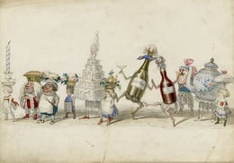
The bold personality of New Orleans’s legendary cartoonist and writer springs from the page in this first monograph of his work by Alison Fensterstock and Michael Tisserand. Preorders available August 1.
On October 29, join us in celebrating six decades of preserving, collecting, and making history. Save the date for music, memories, and more at what is sure to be a fantastic night out in the French Quarter.

edited by Alfred E. Lemmon, John T. Magill, and Jason Wiese; consulting editor, John R. Hébert
See Louisiana like never before, through historical maps tracing the geographical, economic, and cultural development of the state.
HNOC 2003; 2nd printing 2012
hardcover • 14" × 12" • 408 pp.
348 color images
ISBN 978-0-917860-47-8
$105.00
“A monumental achievement, which will no doubt set the benchmark for future studies of Louisiana cartography and historical geography.”
Louisiana History
Published in 2003 to commemorate the bicentennial of the Louisiana Purchase, Charting Louisiana: Five Hundred Years of Maps relates the epic history of Louisiana from European exploration to colonization and development. From the earliest appearance of the Gulf Coast on a 16-century woodcut to a color-enhanced satellite view of the state, this atlas presents an extraordinary gathering of 193 manuscripts and printed maps (all full-color plates), many of them rarely made available to the public. Six supporting essays lead the reader across the historical panorama of Louisiana as found in its cartography.
A must-have for fans of historical cartography, Charting Louisiana is an unprecedented compilation of maps from the extensive holdings of the Historic New Orleans Collection, the Geography and Map Division of the Library of Congress, the Newberry Library, the Louisiana State Museum, and archives in France, Spain, Great Britain, and Mexico.
“It sets the standard for a state atlas. Let us hope that the editors’ lead is followed elsewhere and that the quality of this work is perpetuated.”
Journal of Southern History
“This atlas is remarkable for both its content and the quality of production. It is highly recommended for any library and individual interested in the mapping of America.”
Imago Mundi
One of the most accurate and meticulous maps of antebellum New Orleans is the work of an eccentric 19th-century cartographer.
Rare maps shed light on early exploration, Native Americans, colonial development, warfare and diplomacy, maritime and river navigation, and economic development.
Subscribe to Our Newsletter


